Aim of this project is 1) to increase the effectiveness of water management on flood, drought, and water quality aspects in Upper, Middle, Lower Chi river basins and Lower Mun river basin, 2) to improve the ability on monitoring, forecasting and warning during water crisis, by developing the telemetry system in Middle and Lower Chi as well as Lower Mun river basin as an expansion of the existing system in Upper Chi river basin. The new telemetry system will be integrated with mathematical models, to be developed in this project, to provide forecasting tools for effective water management planning in the basins.
The scope of work for this project comprises of :
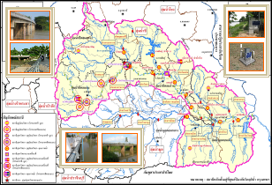
- Study and design of the network of telemetry stations which measure meteorological, hydrological and water quality data. The network shall consist of not less than 15 new telemetry stations which shall be integrated with the 6 existing stations to monitor and collect rainfall, water level (discharge), and water quality data in Upper, Middle, Lower Chi river basins and Lower Mun river basin. There shall be not less than 6 water quality monitoring stations, not less than 12 water level (discharge) monitoring stations, and not less than 15 rainfall monitoring stations. The master station shall be located at Water Crisis Prevention Center, DWR Headquarter, Bangkok with sub master station located at Hydrological division, DWR Regional Office 4, Khon Kaen.
- Study and design of wireless communication system, which uses GPRS or satellite communication system as communication media.
- Study and development of mathematical model including Decision Support System (DSS) which shall automatically perform forecasting and warning in real time, as well as be manually used. The model and system shall cover Chi river basin as well as Lower Mun river basin.
- Construction of field stations. Installation of CCTV system, survey of river cross-section and rating curve at every water-level station.
- River cross sectional surveys shall be conducted at the maximum of 5-km intervals, as well as at the locations of hydraulic structures obstructing the river.
- Supply of hardware and software and system commissioning to ensure that the system can work as specified in TOR.
- Installation of equipment and instruments at master station, sub master station and field stations as well as refurbishment of existing space to fit with at master station, sub master station design (as necessary). The system shall include the integration of the existing telemetry system in Upper Chi river basin.
- Working jointly with DWR’s appointed officials at master station to commission the system, develop operation guideline, and fine-adjust the system for a period of 360 days starting after the project completion date, as well as carrying out technology transfer through on-the-job-training to ensure that the officials have sufficient knowledge and skill to perform at least the following tasks:
8.1 Mathematical Model
- understand principles used for model development
- capable of changing adjustable parameters
- capable of model calibration and verification
- capable of inputting data and conducting model simulation
- capable of interpreting model results
8.2 Telemetry System’s Equipment and Control System
- capable of conducting basic equipment inspection
- capable of adjusting and installing equipment
- have data about equipment manufacturers and suppliers
- capable of equipment maintenance
- maintain field equipment at the minimum of 60-day intervals with DWR’s appointed officials, and in case of every equipment failure
9. Warranty of the system and equipment for not less than 720-day from the project completion date. |