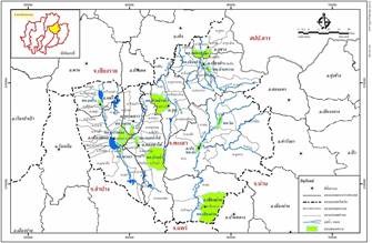
Phayao has areas which suffer flooding regularly. Recent floods in 2005-2006 caused large economic and tourism damages, due to more rainfall than average and overbank flows which inundated farmland and urban areas. To solve flooding problem in communities within municipal and extended communities in Phayao by conducting master plan study in 13 municipalities, feasibility study in 4 municipalities and detailed design for construction for 4 municipalities.
The feasibility studies conducted on the improvement of flood protection and drainage systems for all four municipalities and extended communities are as follow :
1) Mueang Phayao Municipality and Extended Communities
The Consultant proposed to construct flood protection dike along both banks of Mae Tam Canal as well as improving Mae Tam Canal by reshaping and excavating the canal to achieve suitable shape and slope which can convey flood at 100 year return period. The improvement on drainage system consists of the construction of additional main drain in Tambon Wiang to solve flooding in the areas adjacent to Highway No.1. The drain pipes are laid in Susan, Suksan and old Phayothin roads to convey discharge to Kwan Phayao.
2) Dok Khamtai Municipality and Extended Communities
The Consultant proposed to solve flood and drainage problems by constructing flood protection dike along both banks of Rong Chang Canal, diverting excess flow to Rong Rong Canal as well as improving Rong Chang Canal by reshaping and excavating the canal to achieve suitable shape and slope which can convey flood at 100 year return period. The improvement on drainage system consists of the construction of additional main drain in front of Municipal Office to solve flooding in the areas along Highway No. 1251. The drain pipes are laid in Highway No. 1251, and Soi Boon Kerd 3. And drain to Rong hang at Soi Boon Kerd 3.
3) Chiang Kham Municipality and Extended Communities
The Consultant proposed the improvement of Mae Lao River to improve drainage efficiency by excavating the river as well as constructing flood dike along the to construct flood protection dike along both banks of Mae Lao River. The river improvement will include reshaping and excavating the river to achieve suitable shape and slope which can convey flood at 100 year return period. The improvement on drainage system consists of the construction of additional main drain in Pisarn and Sitthipracharat 1 roads to solve flooding caused by insufficient drains.
4) Pong Municipality and Extended Communities
The Consultant proposed to construct flood protection dike along the bank of Ngim/Yom rivers to protect community areas, as well as improving Ngim-Yom rivers and Huai Phae by reshaping and excavating the waterway to achieve suitable shape and slope which can convey flood at 100 year return period. The improvement on drainage system consists of the construction of additional main drain in Khun Yom and Rim Yom Roads.
From the results of economical analysis, it can be concluded that the Feasibility Study for the Detailed Design of Flood Protection Systems for the Community Areas in Phayao has identified 4 areas suitable for the project implementation as follows:
1. Mueang Phayao Municipality
2. Dok Khamtai Municipality
3. Pong Municipality
4. Mae Chai Municipality |